Friday, April 30, 2010

J. W. Bledsoe Photo Co. L. A. Cal: Salt Tram Photographer

Friends of the SALINE VALLEY SALT TRAM
www.SaltTram.blogspot.com   SalineValleySaltTram@gmail.com
As the years pass, researching the true story of the Salt Tram is getting more difficult, as the abundant photos and written first hand accounts from that era find their way into landfills (instead of museums). We  are striving to rediscover the efforts of those who built and ran the Salt Tram, in order to give proper recognition to their hopes, dreams and abundant sweat from an era that is rapidly fading from our memories.  
We are actively seeking out information about the mining of Salt in Saline Valley between 1903 and the 1950's, including: documents, photos, articles, stories, artifacts, etc. If you can help us out, please email us at the address above - Thank-you! --Tim and Brian Waag, the Waag brothers (aka E. Clampus Waagus).
Caution (PLEASE READ): Climbing around on the tramway is dangerous because its really old and defnitely unsafe, so don't even think about it. Shoot, just getting to it requires some perilous hiking, and if you don't believe me, just take a look at the Zig Zag Access Trail (or what's left of it). Plus, climbing on it weakens it and endangers your life. Also, the Saline Valley Salt Tram is on the National Register of Historic Places and should be treated with the respect that it deserves. What little remains is of great historic value, and should not be disturbed in any way. Heck, its probably against the law to move parts of the tram around, and certainly a crime to take home some of the few bits of it that remain (though you'd have to ask your friendly local BLM agent for details). So please treat it with the respect it deserves, so that future generations can enjoy whats left, without you messing it up. Really. Please. You can see its listing on the National Register of Historic Places at these web links:
National Register of Historic Places 1          National Register of Historic Places 2

*********************************************************************************
QUESTION1: Find out more about Bledsoe Photo Co. L. A. Cal. We know that "Bledsoe" photographed the Salt Tram, as the 2 photos below show. Are there more? Who is Bledsoe? There is even less out there about "Bledsoe" than there is about A. A. Forbes, who himself is somewhat obscure (though we hope to change that - see A. A. Forbes Website). 

QUESTION2: Track down Bledsoe photo collections, and see if there are any more Salt Tram photos out there. Any help out there? Please? According to J. W. Bledsoe's great grandson, "there is a good sized collection that belongs to the Los Angeles Department of Water and Power (that is now archived in the USC library)." So we need to track 'em down!

*********************************************************************************
We have 5 Salt Tram photos attributed to "Bledsoe Photo Co L. A. Cal.". Here are 2 of them - Courtesy of the Eastern California Museum (click to enlarge):

Photo 1: Salt Lake workers at north east end of the lake.

Photo 2: Station 7 (note cabin and horses in lower right corner).

*********************************************************************************
Update June 2010: We recently received an email from the great-grandson of Salt Tram photographer J. W. Bledsoe of Los Angeles, Cal. Here is a summary of that email:
"JW Bledsoe was my great-grandfather, and was a photographer active in the west in the late 19th and early 20th century.  He was a commercial photographer, meaning that many of his photos were taken on contract for one or another company, and he often did not retain the negatives or the copyright, hence the sparsity of information on him.  One of his panoramas is held in the Library of Congress, [and] there is a good sized collection that belongs to the Los Angeles Department of Water and Power (that is now archived in the USC library), and we have a few in the extended family.  I'd love to see full-resolution scans of the images you posted. Charles F. Delwiche, Professor, Cell Biology and Molecular Genetics, University of Maryland."
Unfortunately, the J. W. Bledsoe photos of the Salt Tram are small (in physical size), and are probably "proofs" of much larger panoramas. We will send Professor Delwiche what we have, which unfortunately is not of the greatest quality. We do thank the professor for finding our website, and we will follow-up with him.

*****************************************************************************************

Thursday, April 29, 2010

HSUMD Presentation on Tues. 5/18/10 in Ridgecrest, Cal.

Friends of the SALINE VALLEY SALT TRAM
www.SaltTram.blogspot.com   SalineValleySaltTram@gmail.com
As the years pass, researching the true story of the Salt Tram is getting more difficult, as the abundant photos and written first hand accounts from that era find their way into landfills (instead of museums). We  are striving to rediscover the efforts of those who built and ran the Salt Tram, in order to give proper recognition to their hopes, dreams and abundant sweat from an era that is rapidly fading from our memories.  
We are actively seeking out information about the mining of Salt in Saline Valley between 1903 and the 1950's, including: documents, photos, articles, stories, artifacts, etc. If you can help us out, please email us at the address above - Thank-you! --Tim and Brian Waag, the Waag brothers (aka E. Clampus Waagus).
Caution (PLEASE READ): Climbing around on the tramway is dangerous because its really old and defnitely unsafe, so don't even think about it. Shoot, just getting to it requires some perilous hiking, and if you don't believe me, just take a look at the Zig Zag Access Trail (or what's left of it). Plus, climbing on it weakens it and endangers your life. Also, the Saline Valley Salt Tram is on the National Register of Historic Places and should be treated with the respect that it deserves. What little remains is of great historic value, and should not be disturbed in any way. Heck, its probably against the law to move parts of the tram around, and certainly a crime to take home some of the few bits of it that remain (though you'd have to ask your friendly local BLM agent for details). So please treat it with the respect it deserves, so that future generations can enjoy whats left, without you messing it up. Really. Please. You can see its listing on the National Register of Historic Places at these web links:
National Register of Historic Places 1          National Register of Historic Places 2


*********************************************************************************
Update May 2010: Brian and Tim gave an updated version of their 1 hour presentation on the Salt Tram. We don't post the PowerPoint presentation because we have many photos in the presentation that we would prefer would not get onto the internet. Once again, we walk a fine line between sharing information about our Salt Tram exploration (with the hope of finding more sources of information: stories, photos, etc.) and not opening up the area to exploitation and vandalism.

The presentation went well, with what appeared to us as a good turnout, pretty much filling the HSUMD-restored USO Hall (circa 1944). We sold 7 copies of the Henry Clifton Patterson diary at our cost to members in attendance from the HSUMD. If you are interested in a copy, please let us know. We currently have orders for 10 more copies, and are looking for way to get it printed at less expense. We'll let you know when we do.

Before the presentation, we stopped over at the Maturango Museum in Ridgecrest, where we finally met Sandy Rogers, the author of the "Epsom Salts Monorail" book that Tim picked up on the last visit to the museum. We've been trying to get Sandy more interested in the Salt Tram, as we are always looking for researchers and investigators with useful skills for unearthing more data on the Salt Tram. We had previously helped Sandy out by giving him leads on where to find some of the original elevation architectural plans for the Epsom Salt Monorail, which at 26 or so miles long is a similar monstrosity to the Salt Tram. Unfortunately, the monorail is located primarily on China Lake Naval Base property, and nearly impossible for civilians to visit.

We are seeking a few more photos from this 5/18/10 event, including photos of the audience in attendance, as well as photos of Brian and Tim with Andrew Sound, where we are presenting a copy of the Diary to the HSUMD, as well as a 20" x 30" framed copy of the Salt Tram's famous Zig Zag Trail. Note that before the meeting started, Brian, Laura and I were treated to a wonderful BBQ tri-tip dinner put on by HSUMD. Also in attendance at the meeting was Tracy (Desert Mouse) and Mike, as well as newly acquainted explorer Rick S. and his wife (whose name I don't dare attempt to spell here), and Sam W. and wife of Bishop / Keeler. It was also our first meeting with "RubiBlue" aka as Jim Kenney, who is a leader in the HSUMD - we've have exchanged emails before, but this was our first meeting in person - a pleasure! We were also presented with an honorary membership in the HSUMD for 2010 - 2011, and we thank them for that also.


Here are the 3 photos that we have from the presentation (click to enlarge):

Photo 1: Tim and Brian posing out in front of the USO Building in Ridgecrest. To learn more about the building, or to help with finishing its restoration, please contact HSUMD at their website:

Click to go to Historical Society of Upper Mojave Desert website


Photo 2: Brian starting his part of the presentation, inside the USO Building, in front of the stage:


Photo 3: Tim (on the right) with former Keeler (and current Independence) resident John Huerta. Tim and John met at the McDonalds in Lone Pine in 2006, where John first told Tim that "my Dad worked on the Salt Tram!"

*********************************************************************************
Update May 2010: Ridgecrest "News Review" of May 5, 2010 (Thanks to Tracy for scanning this article):

 Above (click to enlarge): Article about May 18, 2010 presentation in the weekly News Review, dated May 5, 2010. To go to the article, click here.   To go to the News Review website, click here.

*********************************************************************************
After our popular presentation on the Salt Tram for the Friends of the Eastern California Museum on March 13, 2010 in Independence, we have accepted an invitation to give our presentation to the Historical Society of the Upper Mojave Desert, aka HSUMD. They tell us that HSUMD is "loosely affililiated" with the Maturango Museum, also in Ridgecrest, if that matters to anyone. We actually don't know what time the presentation will occur or where, but we are hoping they tell us before then - when we know, you'll know! In the meantime, we've provided them with some promo material on our Salt Tram activities, and look forward to buzzing out to Ridgecrest to give the presentation. In the meantime, here's some more info on the HSUMD:

Click to go to Historical Society of Upper Mojave Desert website

Also, since we can't make a post without including a Salt Tram photo, and since there's nothing directly on point for this post, we have picked a random Salt Tram photo (Courtesy Eastern California Museum) from our growing historical collection, and here it is (click to enlarge):


Interestingly enough, this random selection, which we've titled "Just Some Guy", is one of the few photos were we are not sure if it is associated with the Salt Tram or not. Also, like many of our photos, it is out of focus, which is unfortunate. However, given that the HSUMD folks are history buffs, perhaps somebody out there recognizes this person or this location, or perhaps the make, model and year of the automobile off to the right? Anybody?

Tram Power Pole Route

Friends of the SALINE VALLEY SALT TRAM
www.SaltTram.blogspot.com   SalineValleySaltTram@gmail.com
Salt Tram history is rapidly disappearing, and we are striving to rediscover the efforts of our forefathers in order to give proper recognition to their hopes, dreams and abundant sweat from an era that is rapidly fading from our memories. We are actively seeking out information about the mining of Salt in Saline Valley between 1903 and the 1950's, including: documents, photos, articles, stories, artifacts, etc. If you can help us out, please email us at the address above - Thank-you! --Tim and Brian Waag, the Waag brothers (aka E. Clampus Waagus).
Caution (PLEASE READ): Climbing around on the tramway is dangerous because its really old and defnitely unsafe, so don't even think about it. Shoot, just getting to it requires some perilous hiking, and if you don't believe me, just take a look at the Zig Zag Access Trail (or what's left of it). Plus, climbing on it weakens it and endangers your life. Also, the Saline Valley Salt Tram is on the National Register of Historic Places and should be treated with the respect that it deserves. What little remains is of great historic value, and should not be disturbed in any way. Heck, its probably against the law to move parts of the tram around, and certainly a crime to take home some of the few bits of it that remain (though you'd have to ask your friendly local BLM agent for details). So please treat it with the respect it deserves, so that future generations can enjoy whats left, without you messing it up. Really. Please. You can see its listing on the National Register of Historic Places at these web links:
National Register of Historic Places 1          National Register of Historic Places 2

*********************************************************************************
For whatever reason, the electrical power for the Salt Tram ran on separate power poles that ran parallel to and south of the tram line itself. It is likely that nobody has walked this power pole route, since the days when occasional repairs to the power lines were required back in the days when the tram was running. The Inyo Register reported in 1913 that the power lines were hit by a lightening strike that took out 22 power poles, and it is likely that wind occasionally took them down as well.

We would like to walk as much of the power pole route as possible, especially on the more difficult eastern side of the tramway, to see what is there. The photo at right is one of the power poles that is still standing on the west side of the tramway.

Below is a google earth map of the east side of the tramway, where the power pole route is clearly shown. The power pole route was cleared of trees to the same distance as the tram line was, it would seem from the googe earth image.

Note also that in the historic photo below that there are stacked power poles in the foreground, with the bases soaked in creosote (or some other liquid) that would retard their deterioration in the ground. This photo is courtesy of the Eastern California Museum. Click to enlarge.


Tuesday, April 27, 2010

Tram Station and Tower Route

Friends of the SALINE VALLEY SALT TRAM
www.SaltTram.blogspot.com   SalineValleySaltTram@gmail.com
Salt Tram history is rapidly disappearing, and we are striving to rediscover the efforts of our forefathers in order to give proper recognition to their hopes, dreams and abundant sweat from an era that is rapidly fading from our memories. We are actively seeking out information about the mining of Salt in Saline Valley between 1903 and the 1950's, including: documents, photos, articles, stories, artifacts, etc. If you can help us out, please email us at the address above - Thank-you! --Tim and Brian Waag, the Waag brothers (aka E. Clampus Waagus).
Caution (PLEASE READ): Climbing around on the tramway is dangerous because its really old and defnitely unsafe, so don't even think about it. Shoot, just getting to it requires some perilous hiking, and if you don't believe me, just take a look at the Zig Zag Access Trail (or what's left of it). Plus, climbing on it weakens it and endangers your life. Also, the Saline Valley Salt Tram is on the National Register of Historic Places and should be treated with the respect that it deserves. What little remains is of great historic value, and should not be disturbed in any way. Heck, its probably against the law to move parts of the tram around, and certainly a crime to take home some of the few bits of it that remain (though you'd have to ask your friendly local BLM agent for details). So please treat it with the respect it deserves, so that future generations can enjoy whats left, without you messing it up. Really. Please. You can see its listing on the National Register of Historic Places at these web links:
National Register of Historic Places 1          National Register of Historic Places 2

*********************************************************************************
Tram Side: East or West? The Salt Tram is divided in half by the Inyo Summit and the Summit tramway Station. Note that the sections are also indicated on this Salt Tram map, taken from the May 1917 ASCE document.
       
*********************************************************************************
Tram Section (select I, II, III, IV, V): The section of the tram can be ascertained from the May 1917 ASCE map above.

*********************************************************************************
The difference between a Tower and a Station: Below is a photo that illustrates both a Tower (on the left) and a Station (on the right). Note that a Control Station (which is defined as a Station with an electric motor, and is numbered from the Salt Lake as CS 1, CS 2, Summit Station, and CS 4), is also a station, but has a different number; example: Control Station 1 is also Station 7; Control Station 2 is also Station 15, etc. Also, you can see that the Station below on the right also has a Weight Box (aka "WB", aka "Box O' Rox").

*********************************************************************************
Tower or Station Numbering: All numbering starts from the Salt Lake and increases numerically as it goes West towards Owens Valley. The Stations are numbered along the tram route from 1 to 40 or so, as you move towards the West. The Towers are also numbered upwards as you move from East to West, but are start numbering back at 1 at the beginning of each Section. Reference the Station Numbering maps for Station Numbers. Our goal is to number the towers, which has not been done yet.

*********************************************************************************
Tower or Station Latitude and Longitude:  Proper datums need to be used for saving the GPS locations of each of the towers or stations.

*********************************************************************************
Check for all of the following, and document with Video, Photos, Drawings & text description:
  1. Existence of Cables and Wires         
  2. Caliper Guage the Cables  
  3. Sample the wires (note: we aren't allowed to do this!) 
  4. Coverage of Track or Traction Cables, if any
  5. Written markings on structure parts
  6. Dates, names or places stamped in concrete foundations
  7. Camps, tent foundations and dumps in area         
  8. Search nearby ravines for Tram material
  9. Complete Bucket sheet for all carrier parts found       
  10. Weight Boxes and Anchors (which cables)
  11. Measure and map concrete foundations
  12. Measure footprint of entire Tower/Station
  13. State of structure: standing, fallen, etc.         
  14. How much is missing from original tower?

Watterson Family Genealogy

Friends of the SALINE VALLEY SALT TRAM
www.SaltTram.blogspot.com   SalineValleySaltTram@gmail.com
Salt Tram history is rapidly disappearing, and we are striving to rediscover the efforts of our forefathers in order to give proper recognition to their hopes, dreams and abundant sweat from an era that is rapidly fading from our memories. We are actively seeking out information about the mining of Salt in Saline Valley between 1903 and the 1950's, including: documents, photos, articles, stories, artifacts, etc. If you can help us out, please email us at the address above - Thank-you! --Tim and Brian Waag, the Waag brothers (aka E. Clampus Waagus).
Caution (PLEASE READ): Climbing around on the tramway is dangerous because its really old and defnitely unsafe, so don't even think about it. Shoot, just getting to it requires some perilous hiking, and if you don't believe me, just take a look at the Zig Zag Access Trail (or what's left of it). Plus, climbing on it weakens it and endangers your life. Also, the Saline Valley Salt Tram is on the National Register of Historic Places and should be treated with the respect that it deserves. What little remains is of great historic value, and should not be disturbed in any way. Heck, its probably against the law to move parts of the tram around, and certainly a crime to take home some of the few bits of it that remain (though you'd have to ask your friendly local BLM agent for details). So please treat it with the respect it deserves, so that future generations can enjoy whats left, without you messing it up. Really. Please. You can see its listing on the National Register of Historic Places at these web links:
National Register of Historic Places 1          National Register of Historic Places 2

*****************************************************************************************
QUESTION1:  Can you help with the Watterson Family genealogy as detailed below? Thanks in advance!

*****************************************************************************************
As some may know, James "White" Smith (the first President of the Saline Valley Salt Company) was married to Margaret Watterson.  Margaret was born on Isle of Man, England.  She is the sister of William Watterson of Inyo County fame.  More notorious are his two sons, Mark Quayle Watterson, and Wilfred Watterson who owned and operated several banks in the Owens Valley around the time of the Salt Tram thru the late 1920's.  They were also very involved with the construction of the L.A. Aqueduct and some believe they were the brains and money behind the vandalism and dynamiting of same.

Both Mark and Wilfred were convicted of embezzling funds from their own banks and served time in San Quentin.  In fact, the 1930 U.S. Census shows Mark as an inmate in San Quentin in Marin County!  However, the consensus is that many in the valley were very forgiving of their sins as it was believed that much of the embezzled money was used to fund the fight against the building of the aqueduct.

Through research on a genealogy website, we found out that Wilfred passed away in 1941 in Los Angeles, and Mark followed in 1948 and passed in Studio City also in Los Angeles.

NEED HELP!!! - We are trying to locate any living descendants of the Watterson's as we are desperately trying to acquire photographs of White and Margaret Smith!  In addition, there may be additional personal information about them relating to the Salt Tram that would be great to add to our book and are hoping to contact these descendants and find out.  More than likely there are related Watterson's still in the Owens Valley so if any of you blog followers living in Bishop, Lone Pine, etc could help with this, that would be greatly appreciated!!!

*****************************************************************************************

Monday, April 26, 2010

Let's Have Some Fun: Old & New!

Friends of the SALINE VALLEY SALT TRAM
www.SaltTram.blogspot.com   SalineValleySaltTram@gmail.com
Salt Tram history is rapidly disappearing, and we are striving to rediscover the efforts of our forefathers in order to give proper recognition to their hopes, dreams and abundant sweat from an era that is rapidly fading from our memories. We are actively seeking out information about the mining of Salt in Saline Valley between 1903 and the 1950's, including: documents, photos, articles, stories, artifacts, etc. If you can help us out, please email us at the address above - Thank-you! --Tim and Brian Waag, the Waag brothers (aka E. Clampus Waagus).
Caution (PLEASE READ): Climbing around on the tramway is dangerous because its really old and defnitely unsafe, so don't even think about it. Shoot, just getting to it requires some perilous hiking, and if you don't believe me, just take a look at the Zig Zag Access Trail (or what's left of it). Plus, climbing on it weakens it and endangers your life. Also, the Saline Valley Salt Tram is on the National Register of Historic Places and should be treated with the respect that it deserves. What little remains is of great historic value, and should not be disturbed in any way. Heck, its probably against the law to move parts of the tram around, and certainly a crime to take home some of the few bits of it that remain (though you'd have to ask your friendly local BLM agent for details). So please treat it with the respect it deserves, so that future generations can enjoy whats left, without you messing it up. Really. Please. You can see its listing on the National Register of Historic Places at these web links:
National Register of Historic Places 1          National Register of Historic Places 2

*****************************************************************************************
We like to review old photos of the Salt Tram, and then hike around, trying to find where the photos were taken - and then snap a photo that approximates the original as much as possible. We've done a bunch of them, but lets start with a few fun ones, and we can introduce more when we're bored! Hope you like them. (click to enlarge):

This first side-by-side is of Station 11 on the east side of the Inyos.  It is the last tower before the tramline crosses the Daisy Canyon abyss as it heads towards Saline Valley. One can only wonder what it was like to ride the line over the chasm that extends down more than 1,000 vertical feet from the salt buckets!

This next one is also a favorite. On the left is the tramline on its way into the Discharge Station on the shores of Owens Dry Lakebed. The flag hanging from the bucket identifies it as the first carrier filled with salt that made the first of many journies over the Inyo Mountains. The first bucket arrived near Swansea on July 2, 1913 - an amazing 2 hour journey from 1,000 feet of elevation in Saline Valley, to the saddle in the Inyo Crest at approx. 8,500 feet, then down to Ownens Lake at about 4,000 feet. Today, all that is left at this site is an almost completely destroyed tram station at the lip of the ridge, and the concrete foundations of 2 large towers shown in the historic picture at the left.


We were able to obtain this historic photo of 4 men at one of the Salt Tram's many tent cabins. We had no idea where this photo was taken, but we had an idea. In March 2010, we headed up the Swansea Grade to Control Station 4 (Station 29), and sure enough, found the foundation for this tent cabin. Brian and Laura posed as the salt tram workers, and I snapped this shot, which is a pretty good match. I drew the cabin in the modern photo in photoshop to give you an idea of where it stood. Note that Brian is supposed to be imitating the photo by holding a wrench across his knee (unclear on the concept) and Laura is supposed to be holding the cook's spatula (check) and frying pan (oops!).

*****************************************************************************************

Sam's LADWP Sierra Salt File

Friends of the SALINE VALLEY SALT TRAM
www.SaltTram.blogspot.com   SalineValleySaltTram@gmail.com
Salt Tram history is rapidly disappearing, and we are striving to rediscover the efforts of our forefathers in order to give proper recognition to their hopes, dreams and abundant sweat from an era that is rapidly fading from our memories. We are actively seeking out information about the mining of Salt in Saline Valley between 1903 and the 1950's, including: documents, photos, articles, stories, artifacts, etc. If you can help us out, please email us at the address above - Thank-you! --Tim and Brian Waag, the Waag brothers (aka E. Clampus Waagus).
Caution (PLEASE READ): Climbing around on the tramway is dangerous because its really old and defnitely unsafe, so don't even think about it. Shoot, just getting to it requires some perilous hiking, and if you don't believe me, just take a look at the Zig Zag Access Trail (or what's left of it). Plus, climbing on it weakens it and endangers your life. Also, the Saline Valley Salt Tram is on the National Register of Historic Places and should be treated with the respect that it deserves. What little remains is of great historic value, and should not be disturbed in any way. Heck, its probably against the law to move parts of the tram around, and certainly a crime to take home some of the few bits of it that remain (though you'd have to ask your friendly local BLM agent for details). So please treat it with the respect it deserves, so that future generations can enjoy whats left, without you messing it up. Really. Please. You can see its listing on the National Register of Historic Places at these web links:
National Register of Historic Places 1          National Register of Historic Places 2

*****************************************************************************************
We met Sam Wasson, Jr. at the Eastern California Museum in March, 2010, and he had something to show us. It was an old LADWP file on the Sierra Salt Company, pertaining primarily to services provided to Sierra Salt in 1928, though there are documents in the file dated as late as 1938 (unless that was a typo). Anyways, first, we thank Sam for this contribution of a copy of the file for our research, and he has indicated that he may have more to come (we hope so). 

We started this blog for the exclusive purpose of making known our research efforts, just so that we could unearth such documents before they end up in the dump (if they aren't there already!). We have only had time for a cursory view of these documents from Mr. Wasson, and will report here when we have analyzed them in detail. However, suffice it to say that from a quick peek, it is apparent that most of the documents have to do with help from the power company to get the Salt Tram restarted! - how exciting is that! And what a job it must have been. 

In any case, these documents were in the possession of Sam's Uncle, who we are calling Sam Wasson, Sr., before being passed on to Sam Jr. Sam Jr. indicated that they were very close before he passed on. Coincidentally, while doing our periodical research recently, I found a brief article about Sam Jr's Uncle, Sam Sr. As a token of appreciation to Sam Jr. for his contribution to the Salt Tram History, that article from the Inyo Register dated April 24, 1913, is shown below (click to enlarge):

*****************************************************************************************

Salt Tram & the LA Aqueduct

Friends of the SALINE VALLEY SALT TRAM
www.SaltTram.blogspot.com   SalineValleySaltTram@gmail.com
Salt Tram history is rapidly disappearing, and we are striving to rediscover the efforts of our forefathers in order to give proper recognition to their hopes, dreams and abundant sweat from an era that is rapidly fading from our memories. We are actively seeking out information about the mining of Salt in Saline Valley between 1903 and the 1950's, including: documents, photos, articles, stories, artifacts, etc. If you can help us out, please email us at the address above - Thank-you! --Tim and Brian Waag, the Waag brothers (aka E. Clampus Waagus).
Caution (PLEASE READ): Climbing around on the tramway is dangerous because its really old and defnitely unsafe, so don't even think about it. Shoot, just getting to it requires some perilous hiking, and if you don't believe me, just take a look at the Zig Zag Access Trail (or what's left of it). Plus, climbing on it weakens it and endangers your life. Also, the Saline Valley Salt Tram is on the National Register of Historic Places and should be treated with the respect that it deserves. What little remains is of great historic value, and should not be disturbed in any way. Heck, its probably against the law to move parts of the tram around, and certainly a crime to take home some of the few bits of it that remain (though you'd have to ask your friendly local BLM agent for details). So please treat it with the respect it deserves, so that future generations can enjoy whats left, without you messing it up. Really. Please. You can see its listing on the National Register of Historic Places at these web links:
National Register of Historic Places 1          National Register of Historic Places 2

************************************************************************
QUESTION1: Note added 12/1/2010: upon re-reading this material, I find it hard to see how it directly relates to the Salt Tram. We know that the Salt Tram got power from hydroelectric power plants running off of Sierra snow melt. I'll need to check on the exact facts, but the company running these hydroelectric plants in the early Salt Tram era were local plants (Sierra Power? or something like that), and not LADWP who runs them now. I'll leave this in here for now, but need to do some followup on it.

QUESTION2:  In August [what year?], the Watterson brothers (whose bank dominated the valley economy) were arrested for embezzlement; they were later convicted on 36 counts. White Smith was married to Margaret Watterson; Brian will investigate what ties she had to this Watterson Bank embezzlement story.

************************************************************************
From the beginning of our research, it became clear that the destiny of Salt Tram and the coming of Hydroelectric Power generated from the Sierra snow melt, along with the Los Angeles Aquaduct, were intertwined. We have much research still to do in this area, but Brian found an interesting article at:

California Scheming

Here's a brief excerpt from the above link (this article appears to have been OCD'd into text, so we have corrected this excerpt). We will highlight any particularly applicable excerpts.

Tensions between city and valley grew. Litigation ensued, but stalled in the courts. The city bought more valley land, displacing farmers and ruining more local businesses. Finally, valley frustrations reached another boiling point. On May 20, 1927, several men detonated explosives outside Mojave, 100 miles north of L.A., destroying a part of the aqueduct. A few days later, more blasts rocked the aqueduct farther north and, on June 4, still another. A train filled with L.A. detectives armed with Winchester carbines was sent to guard the aqueduct.

Though the detectives had no legal right to do so, they placed Owens Valley under martial law. It didn't help. Over the next two months, seven more blasts occurred at sites along the aqueduct, from Mojave in the south to Bishop in the north, damaging pipes and a power plant and downing telegraph lines.

In the end, what broke the valley's spirit was malfeasance by two of its own. In August [what year?], the Watterson brothers (whose bank dominated the valley economy) were arrested for embezzlement; they were later convicted on 36 counts [note: White Smith was married to Margaret Watterson; Brian will investigate what ties she had to this Watterson Bank embezzlement story]. Some said the brothers had merely been trying to stay afloat financially, and helping others stay afloat, by moving money from one business account to another, recording deposits never made and debits already paid. Their defenders pointed out that none of the money ever left Inyo County. The state's prosecuting attorney, an Owens Valley local and a friend of the brothers, was said to have cried while delivering his final argument. The Wattersons were sentenced to ten years in San Quentin and their five banks closed. Posted on the door of one was the message: "This result has been brought about by the last four years of destructive work carried on by the city of Los Angeles."

Fred Eaton, whose plan to sell his Long Valley ranch was stymied by the city, now had worse problems. His son Harold had mortgaged it to the Wattersons' bank in loans totaling $320,000. When the bank failed, the ranch went into receivership and the city purchased it-for less than the $500,000 Mulholland had offered ten years earlier.

Eaton died in 1934 at age 78, his dreams of fortune unfulfilled. "He was bitter," says his grandson John Eaton, "because he felt he'd been made the goat for all the troubles that came to [ail?] the Owens Valley, and because he felt he never got the proper credit for his role in the creation of the aqueduct."

Mulholland, for his part, died a chastened man at 79, a year after Eaton's death. A dam that Mulholland had built in San Francisquito Canyon, outside Los Angeles, collapsed in 1928, less than 12 hours after he had inspected it and pronounced it sound. A wall of water l00 feet high roared down the canyon, sweeping away trees, homes, cars, a railroad trestle and animals, and killing at least 400 people. Mulholland, although cleared of wrongdoing, blamed himself. He soon retired from the water department and became a virtual recluse, a "stooped and silent" old man, Catherine, his granddaughter, says. (In the 1990s, David Rogers, a forensic geologist who studied the dam rupture, concluded that while there were some flaws in the construction, it was a massive landslide that felled the dam.)

Today most of the people residing in the Owens Valley make their living from tourism, with the majority of skiers, fishermen, campers and so on coming from (where else?) Los Angeles. Some ranches and farms still exist, but most of their fields are leased from the L.A. Department of Water and Power. The bulk of Owens Valley land is empty, its former vitality reduced to groupings of shade trees where houses once stood; long, V-shaped ditches, once used to water fields, now dusty and weed choked; an occasional concrete silo surrounded by sagebrush.

The aqueduct was extended north another l00 miles in the 1940s, to a second large body of water, Mono Lake. Another entire aqueduct was built in 1970 alongside Mulholland's. Almost 100 years have passed since William Mulholland ruled the roost, but for L.A.'s Department of Water and Power engineers, the mandate is still the same: keep the water coming.

********************************************************************************

Sunday, April 25, 2010

Summit Station Stabilization

Friends of the SALINE VALLEY SALT TRAM
www.SaltTram.blogspot.com   SalineValleySaltTram@gmail.com
Salt Tram history is rapidly disappearing, and we are striving to rediscover the efforts of our forefathers in order to give proper recognition to their hopes, dreams and abundant sweat from an era that is rapidly fading from our memories. We are actively seeking out information about the mining of Salt in Saline Valley between 1903 and the 1950's, including: documents, photos, articles, stories, artifacts, etc. If you can help us out, please email us at the address above - Thank-you! --Tim and Brian Waag, the Waag brothers (aka E. Clampus Waagus).
Caution (PLEASE READ): Climbing around on the tramway is dangerous because its really old and defnitely unsafe, so don't even think about it. Shoot, just getting to it requires some perilous hiking, and if you don't believe me, just take a look at the Zig Zag Access Trail (or what's left of it). Plus, climbing on it weakens it and endangers your life. Also, the Saline Valley Salt Tram is on the National Register of Historic Places and should be treated with the respect that it deserves. What little remains is of great historic value, and should not be disturbed in any way. Heck, its probably against the law to move parts of the tram around, and certainly a crime to take home some of the few bits of it that remain (though you'd have to ask your friendly local BLM agent for details). So please treat it with the respect it deserves, so that future generations can enjoy whats left, without you messing it up. Really. Please. You can see its listing on the National Register of Historic Places at these web links:
National Register of Historic Places 1          National Register of Historic Places 2

****************************************************************************QUESTION1:  On upcoming trip in May, make requested photos and videos of summit station.

QUESTION2:  On upcoming trip in May, confirm ASCE 1392 document measurements against structure on the ground. 

QUESTION3:  Supply BWebb with all historic photos of the Summit Station structure.


**************************************************************************** 


April, 2010. Longtime Inyo hiker Brian W. (not the Waag Brother, but another Brian W.) put together drawings in conjunction with Tom B. of the Summit Cabin to facilitate the stabilization of the structure. Lead by then Bishop BLM biologist Kirk Halford, they proceeded to lead a team of volunteers that over many years were able to resusitate the building. Similarly, the team performed critical stabilization tasks on the Summit Station, though in my opinion, they stopped a wee bit short. The purpose of this post is to get the ball rolling with respect to completing the Summit Station project. We have requested that architect Brian W. put together a set of drawing from which the project could operate. In response to that request, he requested the following on one of our upcoming trips, sumarized as follows:
- would be happy to make drawings of summit station
- to help get a jump start on the work, am requesting the following:
     - take photos while walking completely around the structure
     - ditto with video
     - supply with all historic photos of the structure
     - document ASCE 1392 shows a drawing of part ofthe summit station; check to see if measurements are accurate
- this should allow Brian W. to make a drawing before going up to make a final check on the ground

****************************************************************************
Update on July 9, 2010: got indication from BLM that there should be money available in 2011 for Summit Station area restoration activities. We are hoping that there is also money for stabilization activities at Control Station 2. Let the lobbying begin!

*****************************************************************************************

Saturday, April 24, 2010

April 2010: Brian and Alan visit the Summit

Friends of the SALINE VALLEY SALT TRAM
www.SaltTram.blogspot.com   SalineValleySaltTram@gmail.com
Salt Tram history is rapidly disappearing, and we are striving to rediscover the efforts of our forefathers in order to give proper recognition to their hopes, dreams and abundant sweat from an era that is rapidly fading from our memories. We are actively seeking out information about the mining of Salt in Saline Valley between 1903 and the 1950's, including: documents, photos, articles, stories, artifacts, etc. If you can help us out, please email us at the address above - Thank-you! --Tim and Brian Waag, the Waag brothers (aka E. Clampus Waagus).
Caution (PLEASE READ): Climbing around on the tramway is dangerous because its really old and defnitely unsafe, so don't even think about it. Shoot, just getting to it requires some perilous hiking, and if you don't believe me, just take a look at the Zig Zag Access Trail (or what's left of it). Plus, climbing on it weakens it and endangers your life. Also, the Saline Valley Salt Tram is on the National Register of Historic Places and should be treated with the respect that it deserves. What little remains is of great historic value, and should not be disturbed in any way. Heck, its probably against the law to move parts of the tram around, and certainly a crime to take home some of the few bits of it that remain (though you'd have to ask your friendly local BLM agent for details). So please treat it with the respect it deserves, so that future generations can enjoy whats left, without you messing it up. Really. Please. You can see its listing on the National Register of Historic Places at these web links:
National Register of Historic Places 1          National Register of Historic Places 2

*****************************************************************************************
One Saturday in April, Brian and Alan made a mad one-day dash for the Inyo Summit (don't ask why - I didn't). They went up the Swansea Grade and almost made it to the summit road at the Burgess Mine, but came up a couple hundred yards (or so - Tim wasn't there) short, and decided to hoof it to the Salt Tram Summit Station (5 miles - one way). There were in search of the so-called (by us!) elusive Go-Devil route. To find out about that portion of their one day adventure, see the link below:

Alan and Brian find 2 Beam Lumber Pile (scroll down) 
Use RETURN browser button to get back to this web page.

They found mostly dry, bare dirt at the Inyo Summit, interspersed with plenty of huge fluffy white snow drifts of varying sizes from 5 to 10 feet high. Enjoy the photos below, and note that since their trip, the Inyos got another round of snow, though of unknown depth. Note the location of the Summit Road relative to these snow drifts. Tim particularly enjoyed the photo of the Summit Station, as it reminded me of my skiing days on the chair lifts! (note that many tramway manufacturers went into the ski lift business, as they are remarkably similar devices). Click to enlarge:


*****************************************************************************************

Salt Tram Part Numbering

Friends of the SALINE VALLEY SALT TRAM
www.SaltTram.blogspot.com   SalineValleySaltTram@gmail.com
Salt Tram history is rapidly disappearing, and we are striving to rediscover the efforts of our forefathers in order to give proper recognition to their hopes, dreams and abundant sweat from an era that is rapidly fading from our memories. We are actively seeking out information about the mining of Salt in Saline Valley between 1903 and the 1950's, including: documents, photos, articles, stories, artifacts, etc. If you can help us out, please email us at the address above - Thank-you! --Tim and Brian Waag, the Waag brothers (aka E. Clampus Waagus).
Caution (PLEASE READ): Climbing around on the tramway is dangerous because its really old and defnitely unsafe, so don't even think about it. Shoot, just getting to it requires some perilous hiking, and if you don't believe me, just take a look at the Zig Zag Access Trail (or what's left of it). Plus, climbing on it weakens it and endangers your life. Also, the Saline Valley Salt Tram is on the National Register of Historic Places and should be treated with the respect that it deserves. What little remains is of great historic value, and should not be disturbed in any way. Heck, its probably against the law to move parts of the tram around, and certainly a crime to take home some of the few bits of it that remain (though you'd have to ask your friendly local BLM agent for details). So please treat it with the respect it deserves, so that future generations can enjoy whats left, without you messing it up. Really. Please. You can see its listing on the National Register of Historic Places at these web links:
National Register of Historic Places 1          National Register of Historic Places 2

******************************************************************************* 
QUESTION1: Check on the numbering described below ("Update April 2010 from Bob"), regarding markings at the Summit Station.

QUESTION2: Examine Tower below that is well-marked with tower numbering to determine how that affects our assumptions about how these structures were built; some options regarding construction of the "Stick built" nature of Towers and Stations:
  1.  "Stick built", numbered and pre-drilled bolt holes with powered drill presses at the timber mill in Oregon from whence they came, then shipped by rail to the Salt Tram and "reassembled" in the field.
  2. "Rough cut lumber" from Oregon shipped to the Salt Tram Discharge Station, and then processed as in no. 1 above.
  3. "Rough Cut Oregon Lumber" transported to Station and Tower sites, with wood cut and drilled bolt holes on site.
QUESTION3: Take a photo on the westside of the tramway to match the historical photo below (the one showing the spooling of the cable over the westside of the tramway.
 
 ******************************************************************************* 
The construction of the Saline Valley Salt Tram, along with the associated facilities at the Salt Lake to collect the salt, the Loading Station, and the Discharge Station, was a complicated affair. It was performed during a time without cell phones, satellites, or other wireless communication of any kind (heck, cell phones don't get a signal out in Saline Valley to this day). Coordination was crucial, and to support the goal of having tram parts coming off the railroad from Trenton New Jersey (home of Trenton Iron Company, who designed and built the tram parts), they were frequently numbered. One of our goals when we examine the tram is to observe all notations on the manmade tram parts to further our knowledge of how the tram was constructed.

Below is an excellent example of a tram part at the Summit Station (Control Station 3 and Station 20) that is labeled with the Station number. This photo was taken by Alan E. Click to enlarge.


Below is another recent example of tram parts being labeled with the Station Number. In this case, this is a photo taken by Tim in March, 2010 at Station 29. This photo is of the side of the Weight Box at Station 29, and clearly marked with "S. 29". Click to enlarge.


******************************************************************************* 
Update April 2010 from Bob:
 Tim, In reference to your post on Salt Tram Part Numbering. April 24

I forgot to mention to you in my previous e mail about the location of a marking on a beam located in the Summit Control Crossover Station. You may have already seen it but If you have not I wanted to bring it to your attention as it is hard to see. I am not sure at this time if it is a letter & a number or just numbers.

Standing inside the tram station looking down the right hand tram cable line which goes down to the Owens Valley. The location of the marking is on a large wooden timber that the outside metal sheeting is nailed to. It is to the right of the cable line and about 10-12 feet up from the wooden floor. When I first saw the markings I thought that the Tram Station had been built down in the valley and then assembled up on top. Good luck.  Regards, Bob

*******************************************************************************
We discover much about the Saline Valley Salt Tram by spending hours looking over the 100's of scans of old photos which are in our posession due to the generosity of the Eastern California Museum of Independence, who in their infinite wisdom has seen fit to let us scan their Salt Tram collection for our use in doing this "knowledge excavation" that is found on this web site. Below is a photo that has decent resolution (most do not), and depicts activities that greatly expand our knowledge of the tram's construction. First, let's look at the entire photo (click to enlarge):
This westside tram photo above shows a number of important Salt Tram Construction activities:
  1. A large number of men (10 to be exact) engaged in tram construction activities.
  2. A closeup of the various clothing worn in construction of the Salt Tram
  3. One of only two known photos of cables being strung out along the tramway. In this instance, the photo shows a harnessed pair of mules playing out a Salt Tram cable (which appears to be the 7/8" traction cable), which is draped over the traction sheave of the Tower.
  4. At the base of the Tower in the foreground is a cable spool being played out by 3 men at the base of (and inside the footprint of) the Tower. We believe that the Tower was used as a support for the base of the heavy cable and despooler, as much force must be applied to the cable to despool it. Note that this cable is NOT the one that is being played out by the mule team, distanced ahead in the photo.
  5. In the foreground are 4 or 5 tram power poles, with their ends coated in a black substance (creosote) to protect the wood that is buried in the ground from rot (note that it has worked well, as most tram power poles that were not sawed off at the base to salvage the copper wire are still standing). This indicates that the Tram Stations and Towers were built before the Power Pole installation was completed, unless for some reason that these are extra poles that happened to be stored in this location - unlikely, in our opinion.
  6. Last and very important: each of the beams, including one of the ladder cross pieces (!) is labled with "23 C 4", which I interpret to mean Tower 23, Section IV (although this will need to be calcualted and verified).
Anyways, here is the photo, with an enhancement in photoshop at right to make the markings more clear:
 On an interesting side note, we believe that we have located this tower, and it is one of the rare westside towers that are still standing, owing largely to its distance from the road. It has not, as you shall see, escaped all vandalism. Let's take a look. First, here is a location that matches that of the full size photo above:
The photo above shows the 3 towers (A, B, C) located above (or east) of the marked tower in question. We note with fascination that Tower B was lowered from its original construction, as one of the many "tweaks" to the tramway to make it function properly. Below shows the same towers A, B and C in our historical photo:

Unfortunately, we don't have a modern photo (but we will!) of Towers A, B, C and what we shall call Tower D (the one with the "23 C 4" markings on it), but I believe we do have a photo of that tower by itself, and here it is:
This photo shows Brian standing at the base of this Tower D (aka Tower "23 C 4"). Note the discrepancies with the historical photo of this tower: there are no horizontal boards at the base, which would seemingly rule it out as the same tower. However, note a detail of the photo above:
It seems that the original horizontal and diagonal beams were attached to this tower, but removed, as evidenced by the red box in this photo; you can also see the bolts sticking about where the cross beams were removed. Plus, both towers have 6 ladder steps nailed into one of the four corner supports, and it is the same corner as in our historical photo. Seems pretty conclusive to me!
    *****************************************************************************************

    Wednesday, April 14, 2010

    Patterson Diary: Camps, People & Places

    Friends of the SALINE VALLEY SALT TRAM
    www.SaltTram.blogspot.com   SalineValleySaltTram@gmail.com
    Salt Tram history is rapidly disappearing, and we are striving to rediscover the efforts of our forefathers in order to give proper recognition to their hopes, dreams and abundant sweat from an era that is rapidly fading from our memories. We are actively seeking out information about the mining of Salt in Saline Valley between 1903 and the 1950's, including: documents, photos, articles, stories, artifacts, etc. If you can help us out, please email us at the address above - Thank-you! --Tim and Brian Waag, the Waag brothers (aka E. Clampus Waagus).
    Caution (PLEASE READ): Climbing around on the tramway is dangerous because its really old and defnitely unsafe, so don't even think about it. Shoot, just getting to it requires some perilous hiking, and if you don't believe me, just take a look at the Zig Zag Access Trail (or what's left of it). Plus, climbing on it weakens it and endangers your life. Also, the Saline Valley Salt Tram is on the National Register of Historic Places and should be treated with the respect that it deserves. What little remains is of great historic value, and should not be disturbed in any way. Heck, its probably against the law to move parts of the tram around, and certainly a crime to take home some of the few bits of it that remain (though you'd have to ask your friendly local BLM agent for details). So please treat it with the respect it deserves, so that future generations can enjoy whats left, without you messing it up. Really. Please. You can see its listing on the National Register of Historic Places at these web links:
    National Register of Historic Places 1          National Register of Historic Places 2

    *****************************************************************************************
    QUESTION1: Find out as much as we can about Earl Patterson, Cliff's  brother and co-worker on the building of the Salt Tram. When was he born? Did he marry and have children. What do we know about the relationship between brothers Cliff and Earl. Etc.

     QUESTION2: Find out as much as we can about Burney Patterson, Cliff's brother. When was he born? Did he marry and have children. What do we know about the relationship between brothers Cliff and Earl. Etc.

    *****************************************************************************************
    We have been slowly working our way through the Inyo Register "IR" (Bishop, Cal.) and the Inyo Independent "II" (Independence, Cal.) during the Salt Tram era to advance our Salt Tram knowledge. While working on the years 1911 - 1913 in the Inyo Register, I decided to first review every page of the Patterson Diary for potential references that I would want to keep an eye out for while reviewing the IR. Specifically, I was looking for Construction Camp Names, Current Events noted in the diary that could be found in the IR, People and Animal Names noted in the diary, and cities or regions noted in the diary. Below is the result of that work.

    Camp Names and References
    12/1/1911 Dry Camp
    12/21/1911 Gravel Pit
    1/5/1912 Gravel Camp
    2/13/1912 Dry Camp
    2/17/1912 Telephone
    2/25/1912 Gravel
    3/8/1912 Gravel
    3/8/1912 Charcoal
    3/11/1912 Los Pinos
    3/12/1912 Gravel
    3/15/1912 Charcoal
    3/29/1912 Gravel
    4/2/1912 Gravel
    4/3/1912 Daisy Canyon
    4/10/1912 Daisy Canyon
    4/23/1912 Gravel
    5/4/1912 Daisy Canyon
    7/15/1912 Camp at Station #26
    7/21/1912 Flagstaff
    7/22/1912 Flagstaff
    7/21/1912 Flagstaff
    8/23/1912 Daisy Canyon
    9/14/1912 Daisy Canyon
    9/30/1912 Sta. #7
    11/30/1912 Terminal
    1/16/1913 Station 29 (Control Station 4)
    1/16/1913 Old Dry Camp
    2/24/1913 Chuckawalla
    3/20/1913 Chuck (awalla?)
    3/25/1913 Chuck (awalla?)
    3/26/1913 Chuckwalla
    3/27/1913 Chuckwalla
    3/28/1913 Chuckwalla
    5/18/1913 Chuckwalla
    5/19/1913 Summit
    5/20/1913 Daisy
    5/26/1913 Daisy Camp
    6/2/1913 Summit
    6/2/1913 Daisy Camp
    6/3/1913 Daisy Camp
    6/26/1913 Moved up to (station) 29
    7/9/1913 Deep Canyon
    7/10/1913 Deep Canyon

    Topics to look up in the Newspaper
    12/13/1911 Voted Dry
    8/21/1912 Went to the Trial of Zachary
    9/13/1912 Chas. Bigelow got drowned.
    10/22/1912 Layed out Saline terminal and check up bolts and shortage of towers up to Tower #29.
    10/29/1912 Another Englishman came.
    4/21/1913 Bunch of Big Guns came.
    4/28/1913 Japs came down.

    People/Visitors and/or Animal Names
    12/8/1911 White [Smith] came up to see us today
    12/15/1911 Left Bishop for Swansea with Will Smith
    12/17/1911 White [Smith] came up and learned to concrete
    12/21/1911 Packed up Beanny with Earls and my beds … then loaded them on Boots wagon
    12/22/1911 …did some surveying for W. Y. Davies
    12/26/1911 Ate Turkey Dinner at Dr. Stofflets
    1/4/1912 Moved down to Saline and helped Mr. Wickham with cross sectioning…
    1/5/1912 Went up to where muled got Killed and got Apperajo
    1/6/1912 Al, Earl and I leveled up T’s…
    1/10/1912 White and Will came down tonight in the Auto.
    1/18/1912 Earl and Al  went up and leveled Tower #20 Section 5.
    1/30/1912 White and Will came in the Auto.
    2/25/1912 Slept in Bowman’s Tent.
    2/27/1912 Graded out for Tents in A.M. and worked on Station #26 in P.M. Al, Earl and I.
    2/28/1912 Put up Tents in A.M. & worked on 26 in P.M. Earl & I and Al a part of A.M.
    3/8/1912 Went to Gravel & got Trix and packed 1 sack grain to camp…
    4/30/1912 White, Pen & another Tenn. Gink and Dad came up to got Summit.
    5/1/1912 Dad went to Saline.
    5/6/1912 Wallace took Williams place.
    5/19/1912 run levels in PM with Mr. Wickham.
    5/22/1912 …Then had to tear out 7 & 8 on acct of mixup of Kuhn lo’s
    5/24/1912 Jeff & Tolly cut off anchor bolts in afternoon
    6/4/1912 Took shore line & levels of Lake with Earl.
    6/7/1912 Run levels for Coward AM.
    6/9/1912 Layed out Vats for Coward.
    6/11/1912 Layed out Vats #2, 3, & 4 East for Coward & set elev. For #2
    7/16/1912 Earl went to Swansea to mail letter.
    7/23/1912 White came up and gave me a letter from Fred.
    7/21/1912 Reed & one of Ben’s gang put up tent at flagstaff.
    7/22/1912 Jeff, Bill and two of Ben’s crew commenced excavating on small piers…
    7/23/1912 Jeff put up Shop and Meeker flunkied.
    7/26 – 8/21/1912 Cliff vacationed in Yosemite – will do the names for these dates later
    8/24/1912 White, Wickham, Albright and Dan’s kid came from Saline
    9/4/1912 Earl went to Bishop
    9/16/1912 Hiram put out Dog poison
    9/28/1912 Earl came back & White with a bunch of Gazoboes came up from Saline.
    9/29/1912 Billy the Cook left for Saline and Sam the Chink took his place.
    10/9/1912 Worked on Machine Pit. Earl & I.
    10/31/1912 Went up to Sta #7 and set forms, Earl & I.
    11/17/1912 McKaye & I worked on Sta. #2.
    11/19/1912 Mc and I worked on Sta #2.
    11/20/1912 Mc & Jim (Welch) & I worked on Sta #2.
    11/21/1912 McKay and I worked on Sta #2.
    11/25/1912 Raised four Bents of Sta#4. Bill quit.
    11/27/1912 Raised end braces for Sta #4. Earl left for Bishop.
    12/4/1912 Worked on Sta #1. Earl came from Bishop.
    2/4/1913 Worked on Sta #31. Earl  & Marion came up to 29 in the morning.
    2/19/1913 Worked on Towers 1 to 14. Earl & I.
    2/20/1913 Earl & I worked on Towers 14.-22.
    3/2/1913 (Nancy Hanks had company).
    3/4/1913 Worked on Sta #4 (Chicken Dinner) Don’t tell Ned.
    3/8/1913 My Hunkle came down and got the mail.
    3/19/1913 Skinned mules stringing cable. Hiram, Mr. & Mrs. Pearl and little girl Taber came.
    3/25/1913 Moved the bunch to Chuck and hauled water P.M. Schober & Keller arrived.
    3/26/1913 Hauled cable up to Chuckawalla with Bill Keller’s team.
    4/17/1913 Finished taking in tension between Sta #1 & 2. Bolser came down.
    5/12/1913 White and Will came over to Saline.
    6/16/1913 Got letter from Mama.
    6/22/1913 Had some chicken and cake that Dell made, and it was fine.
    7/13/1913 Run tram all day. Hayes came from 20 – 39 in bucket.
    7/16/1913 White came up and gave us some toffee.
    7/18/1913 Run tram all day. Earl got oxcited.
    7/22/1913 Eric came down and helped on guides.
    8/9/1913 Ran tram all day. Bolser came up and fixed phone and moved it.
    8/10/1913 Run Tram 30” to get men off line after Ring down from 39. Mrs Mc came to Swansea tonight.
    8/11/1913 Ran tram all day & Oh Joy! No more cooking for Carl’s wife came up this A.M.
    9/11/1913 Run tram & worked on Sta. Got box tomatoes corn cucumbers from Mr. McAfee.
    9/13/1913 Run tram all day. Got box tomatoes, corn, cucumbers, peppers, beets, str. Beans. Mrs. Mc
    9/29/1913 Run tram & worked on Sta. Had to run till 6:06 to get Murphy & another Geezer over from Saline.
    10/20/1913 Run tram all day. Mrs. Kuhnle, Mrs. Jones & Pearl Tabor went to Saline and back on tram.
    11/22/1913 Stayed in bed. Earl & Anita came to see me. 

    City References
    Swansea
    Bishop
    Chalfant
    Paradise Valley
    Los Pinos
    Laws
    Lone Pine
    Keeler

    *****************************************************************************************
    You will see in the section "People/Visitors and/or Animal Names" (above) that the name "Earl" (no last name given) pops up frequently. I wondered why. Then I found this article in the Inyo Register on October 30, 1913 (click to enlarge; see yellow highlight):


    When the Salt Tram first shut down in the fall of 1930, all the workers were laid off, and many returned to their local towns in the Owens Valley. There is a column in every edition of the IR named "TABOOSE". I don't know what that word means (more on this later), but it is a local Owens Valley place name. However, the column is used to advertise the comings and goings of local dignitaries and visitors. Lo and behold, we find this entry (highlighted in yellow above) in the October 30, 1913 edition of the IR:

    "Clifton and Earl Patterson, H. Wood, Dugald McKennon, (sp?) and Howell McKay returned to Bishop this week from the Saline company's works."

    Wow! Earl must be Cliff's brother. Indeed. Immediately pulling up the Patterson Family Photo Page website (maintained by Byron Patterson, grandson of Cliff Patterson) at:

    Patterson Family Photos

    I immediately saw this photo (click to enlarge):
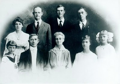


    Along the top row, left to right, are the 3 brothers: Burney, Cliff and Earl Patterson! The older 2 adults in the bottom row of the photo are Rev. S. S. Patterson and Belle Patterson, the parents of the Patterson boys in the top row. I was excited to learn that the "Earl" mentioned all those times in Cliff's Diary was none other than his brother Earl. The earlist reference to Earl in Cliff's diary is on December 21, 1911, and the last reference is July 18, 1913, indicating that Earl and Cliff worked together at least 18 months on the Salt Tram and probably more. We will find out more about this as soon as we can. I contacted Byron Patterson to find out more about Earl and his descendants, and hopefully there will be more to report soon.

    When I spoke with Byron regarding this, he indicated that Cliff's brother Burney may have been a minister and followed in the footsteps of his Dad, Rev. S. S. Patterson. When we find out more, we will report back here.

    *****************************************************************************************